
DJI Mini 2 DNG | 4.5mm | 1/640s | f/2.8 | ISO 100
This month post is a special one. Going to show you a few beautiful landscapes photos from above the Arctic Circle. The landscape in the far north is spectacular. Along with daylight that last the full 24 hours of the day, the hard part is staying awake to enjoy it all.

300mm | 1/125s | f/5.6 | ISO 64
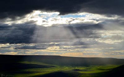
The landscape of the north is vast and open. The image above was painted with light as the sun broke through the clouds and highlighted the water channels, now dry, from spring water run off. This area along with the opening drone landscape photo is along the Yukon and Northwest Territory border through the Wright Pass of the Richardson Mountains.

300mm | 1/1000s | f/5.6 | ISO 1400
Fireweed flowers often grace the land in the north. It is the floral emblem of Yukon Territory. Best time to see the fireweed flower is in July.
Traveling further north, you leave the mountains behind and come upon the great Mackenzie River Delta. This area is 210 kilometres from north to south and 50 to 80 kilometres wide. It is the second largest Arctic river delta in the world. This area consists of permafrost, which is soil that continuously stays below freezing year-round. Unique landmarks near the Arctic Ocean are Pingos, which are intrapermafront ice-cored hills. In the river delta where the land barely rises a few meters, these scattered hills are quite impressive. This is Ibyuk, the largest Pingo in Canada and the second largest in the world!

70mm | 1/250s | f/7.1 | ISO 320
In a landscape with no trees, this Pingo and the driftwood lining the Arctic Ocean shoreline created a view of uniqueness.
My trip to the far north was a completion of a project to travel Canada by car from coast to coast to coast, that is Pacific Ocean to Atlantic Ocean to Arctic Ocean. One day, I hope to put create a photography book of these adventures. I had traveled as far north as one could back in the late 1990s when the road ended at the town of Inuvik, NWT. The Arctic Ocean is about 125 kilometres further north of Inuvik. Then in 2017, a new highway, Inuvik-Tuktoyaktuk Highway was open and that started my return to the Arctic project and to make it to the Arctic Ocean. After several delays and setbacks, I finally made it in the summer of 2022. Here is the end of the road at Tuktoyakuk, NWT.

DJI Mini 2 DNG | 4.5mm | 1/640s | f/2.8 | ISO 100
I enjoyed 2 nights camping on the edge of the Arctic Ocean on this narrow bit of land at the end of the road. I’m sitting at my campsite on the edge of the ocean while using the drone to look back towards the town of Tuktoyaktuk with the Pingos in the distance and the Arctic delta stretching into the distance.
One morning while enjoying my coffee and enjoying the peaceful views out to sea, I spotted a Beluga whale breach and then disappear. I then quickly grabbed the camera and big telephoto lens and then watched the water for a while, but sadly it had moved on. Still a special sight to glimpse a whale at my campsite. Talking to locals, it is rare for them to come that close town. Here is the view from my campsite looking northwest out across the Arctic Ocean. The evening sun still high in the sky at 7pm.

5 frames pano @ 24mm | 1/160s | f/16 | ISO 100
Growing up in the north, I am no stranger to exceptionally long daylight days, but something I always wanted to experience was the 24 hours of daylight. My trip to Inuvik in the late 1990s was in July and that location was a bit too far south as the sun set below the horizon for a brief time over night. Traveling that little bit further north, I was able to experience the sun that never sets. The first night I was there, clouds covered the full sky and it felt like noon all day and night long. Got to witness forever daylight, but the goal was to see the sun that slides down to the horizon but never sets below and then start rising back up. Using an iPhone app, PhotoPills, I learnt that at 3:30am the sun would be just above the horizon before it started the path back up. I stayed up all night, only having a few micro naps and getting up regularly to check the views. I placed a GoPro on the edge of the ocean and timelapse the sun’s path in the sky. This timelapse video was taken from midnight to 6am.
And this photo is the sunset and sunrise, all that the same time at 3:30am.


24mm | 1/6s | f/16 | ISO 100

This signpost at the end of the road pointed out just how large and vast this landscape is. The sign said that the North Pole was still 2287 kilometres away! As the bird flies. To put into perspective how much effort it takes to get to the Arctic Ocean, I was 2215 kilometres from home, as the bird flies. By car, that was like 3600 kilometres of road.

24mm | 1/6s | f/16 | ISO 100
The next blog post will be Part 2 with more impressive landscapes of the Arctic.


0 Comments